Where am I going? Where am I? How do I get back to camp?
We’ve all been there. With the adventures that our UTVs take us on, we all want to explore farther. The problem is, when we go to new places or find unfamiliar areas, it’s easy to get lost when surrounded by trees that all look the same or in a maze of canyons in the desert. A good GPS is one of the most invaluable accessories you can own.
The biggest thing you need to figure out before you start running a GPS is what kind of device you want. Dedicated offroad GPS devices can generally feel familiar to you if you’ve run a regular GPS before and come from trusted brands like Garmin and Magellan.
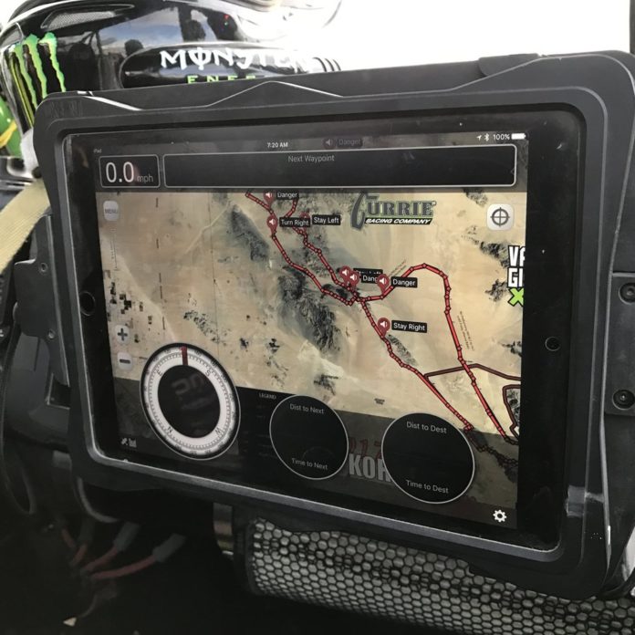
However, for versatility, many people love running a tablet using Android or iOS offroad GPS programs. Tablets can be as accurate as dedicated offroad GPS devices, but generally have a bit more of a learning curve. The biggest upside is that you can use your tablet to control other devices like a GoPro, your music library at the same time as using the GPS app. Additionally, you can experiment with different GPS programs to see what you like the best as opposed to being locked into one interface like a dedicated GPS.
Magellan TRX7 CS

The TRX7 CS comes preloaded with over 160,000 designated OHV routes from forest and public lands and includes Magellan’s award-winning street navigation to get you from your starting point to the trail. Search trails using your TRX7 CS or search for trails in a constantly growing crowdsourced track database. Magellan’s trail database contains over 160,000 OHV routes and user-generated tracks created by fellow off-roaders. The community database is accessible by desktop, tablet, or mobile device. Crowd-sourced tracks contain personal observations so that you can search for them by location, track difficulty, rankings, and more.
You can also review trails and their attributes before you head out to the trail, then save to a list of favorites for future rides. View satellite map imagery when you search for trails and read all of the observations and rankings to get the latest trail information so that your off-road adventures are safer and more enjoyable.
The TRX7 CS’s intuitive interface makes following trails and recording your own tracks simple. Using either a saved trail from your favorites or a preloaded trail on the device, simply tap “Follow” once the trail is selected. Once you’re on the trail, the TRX7 CS helps identify land features and minimize surprises for safer off-road navigation by providing a high-resolution 3D terrain map view and a 2D topo view with contour lines that cover the USA and Canada.
With one touch, you can also start tracking while you’re driving, and the TRX7 CS automatically starts bread-crumbing your track. When recording a track, the TRX7 CS makes it easy to save waypoints and any notes you want to record. While tracking, TRX7 CS limits you to selecting only a waypoint type. With a few quick taps, you can save a waypoint to your track with no hassle. When you stop your vehicle and pause tracking, the TRX7 CS allows you to do a much more detailed waypoint creation. Once paused, you can mark waypoints using audio recording, coordinates, current location or point on map, or you can select a type of waypoint, name it, add photos, and more. When you save or publish your track, all of your waypoints and observations are saved with the route so the next off-roader following your track will know about any obstacles or beautiful views that await them.
Just because your out in the wilderness doesn’t mean you have to be offline if you don’t want to be. You can share your trip with friends and family with the Social Post button, which sends an automatic preconfigured Tweet from the trail. Your Tweet will post right away if you’re using your phone as a hotspot, or it will automatically send once the TRX7 CS is connected to Wi-Fi. When you’re doing it for the ‘Gram, you can link your Twitter and Instagram accounts, and you can share your trail updates and photos with your social network. When navigating a track with saved waypoints, you’ll see pop-ups notifying you of any upcoming waypoints. By giving off-roaders access to this information, you can be more aware of your fellow off-roaders’ observations for safer and more enjoyable trail riding experiences.
Other TRX7 CS safety features include off-course notifications and Backtrack. The TRX7 CS warns you whenever you veer off course to quickly get your vehicle back on track. At any point along a track, select the Backtrack feature and you’ll be guided safely back to the trailhead, campsite, or any current track starting point.
The TRX7 CS is waterproof, dust proof and ready to take on any adventure you want with its 7″ touch screen display. The Magellan comes with a RAM mount to hold your device and is supported by free lifetime map and software updates.
Magellan TRX7

If you’re not doing it for the ‘Gram and don’t need the camera and social media aspect of the TRX7 CS, then the Magellan TRX7 can save you a good chunk of money, but get still get the rest of the features of the CS. All of the internal specs of the device are the same and on the outside, you still get the mounts, the shockproof housing and all the water and dust resistance of the higher end model.
Garmin Overlander

This is the latest and greatest GPS from Garmin. Built for every part of the journey, the Overlander is the rugged, all-terrain navigator with on the road and offroad navigation. This device takes care of the best of both worlds for areas where UTVs are street legal.
The Garmin features a 7” color touchscreen features turn-by-turn directions for on-road “turn-by-turn” navigation and topography maps for off-road “point-to-point” guidance in North and South America. The Overlander is built to the U.S. military standard 810 for thermal and shock resistance and can be mounted anywhere, thanks to the powered magnetic mount that comes with suction cup and 1” RAM ball compatible adapter. The device is rated IP5X, so we would have no issues running it in dry conditions, but do have some concerns about how well it would hold up in wet conditions. Ram Mounts does make a product called the Aqua Case that could be used to house the Garmin, but it’s bulky. We’d really like to see Garmin address this.
Users of the Overlander can use the Garmin Explore app to download additional maps — such as satellite imagery and USGS quad sheets on 64 GB of internal storage. You can also easily import and export GPX files to Garmin Explore, even if you’re offline. GPX files are the most commonly used files available for user generated tracks. One feature we haven’t seen other offroad GPS manufacturers come up with is available on this device. You can view your UTVs pitch and roll angles, which can give you a heads up if you’re going too far off camber or getting on something too steep.
Apple iPad

If you’re going to get an iPad for going offroad, it is best to get their “WiFi+Cellular” models, since those are the ones that have a built in GPS chip. You don’t have to sign up for a mobile data plan to use them, but for whatever reason, Apple only includes the chip in those models. However, you can still get away with using an iPad WiFi only model, but you will need to purchase an external GPS receiver like the Dual XGPS160. We actually recommend these for any tablet that you want to run GPS on. They’re more accurate than even dedicated GPS devices and have a significantly faster refresh rate for recording tracks. The XGPS160 is actually rated up to 1,150 MPH!
The iPad seems to run GPS more efficiently than Android devices and why we recommend it first. Even with older generation iPads, GPS programs run smoothly and are very responsive.
For offroad navigation, there are a host of apps available, however our favorite is the MobArmor GPS app. It has a host of built in features, but is very easy to learn. It can be downloaded for free and costs less than $20 to unlock all its features. For racing, the iPad along with LeadNav is a hugely popular application.
Samsung Galaxy Tab A

The Galaxy Tab A from Samsung is one of the most affordable tablets available with the horsepower to run GPS well, featuring 2 GB of RAM and 32 of internal memory expandable up to 512 GB with a microSD card. The Galaxy Tab A has a chip that receives signals from GPS, GLONASS and BeiDou systems, with accuracy up to six meters. The Tab A comes in two screen sizes. An 8″ screen version as well as a 10.1″ screen. We also highly recommend pairing this with the Dual XGPS160 external GPS receiver to improve speed and accuracy within 2.5 meters.
Since the Samsung is on the Android platform, there are thousands of free and paid apps to play with the on the tablet and accessories are all fairly inexpensive, including weatherproof cases.
For offroad navigation, there are tons of apps available in the Google Play store. For Android devices, we love Backcountry Navigator, which is free to try. For a one time $14.95 fee, you can upgrade it to Backcountry Navigator Pro, which gets you all the features of BCN for as long as you own the product. The sheer amount of features of BCN give it a bit of a learning curve, but it is one of the most feature rich offroad GPS apps on the Android market today.


